When it comes to skiing, one thing you really do need over anything else, is snow. You don’t necessarily need a massive amount of it, but there’s nothing quite as bad as having an expensive ski holiday spoiled by a poor snow cover or soggy snow! With climate change and global warming very much a reality, snow conditions in ski resorts are becoming increasingly unpredictable. Consequently, many enthusiasts are gravitating towards ski areas known for consistent snowfall to ensure a gratifying skiing or snowboarding experience.
But where to go? Which are the best snow-sure ski resorts in the Alps?
The Alps, a prime skiing destination, are subject to the impacts of climate change, an issue often overlooked by wintersport enthusiasts. However, it’s undeniable that the changing climate is reshaping the skiing landscape. Notably, several small low-altitude Swiss and French resorts have already become unviable, and for similar ski resorts it is getting harder and harder to provide a good-quality snow cover during the ski season.
The warming of the Alps is occurring at a pace faster than the global average, a phenomenon not yet fully understood by researchers. The primary concern isn’t just the rising temperatures but also the erratic nature of weather patterns, extreme weather events, and stalled weather systems. Additionally, a phenomenon known as seasonal drift has altered the coldest periods in the Alps, pushing them from December to the early months of the year. Spring snow melt is occurring earlier in the year, effectively shortening the ski season. In the Southern Alps, which typically receive less snow than their northern counterparts, there’s been a more significant decrease in snow depth below 2000 meters. Regional trends sometimes differ considerably. So, what can we learn from the recent past?
Given these changes, the quest for snow-sure ski resorts often leads to high-altitude locations where deeper and higher-quality snow is more likely. However, disparities in snow depth and quality are still evident among different resorts. Claims of snow surety by many resorts may not always be substantiated and could be influenced by marketing strategies or over-reliance on artificial snow-making.
There’s a trend among various winter websites and blogs to compile lists of snow-sure ski resorts, which entails in arguable and unsubstantiated claims of the ‘snowiest ski resorts’. Such rankings often leave out numerous viable alternatives, raising questions about their accuracy and the data sources used.
The focus on a top ten means that a lot of interesting snow-sure alternatives are left out-of-scope and umentioned. That does not seem to be fair. We would like to know what can be said about the level of snow reliability of neighbouring ski resorts and those at lower altitude.
Not the snowiest, but the most snow-sure
Addressing these issues, SkiWeather.eu has embarked on extensive research over the past decade, analyzing a vast array of snow and weather data (over 30 million records) from multiple sources. The objective is to assess ski resorts based on a combination of snow depth and temperature. This approach differs from merely identifying the snowiest resorts; it focuses on consistent snow conditions throughout the ski area, especially considering that snow depth at higher elevations doesn’t always reflect the conditions lower down.
In this research, over 1,500 ski resorts were evaluated based on weekly average snow depth on both lower and upper slopes, along with temperature variance. This method considers both the quantity and quality of snow, as well as consistency in temperature. To provide a balanced assessment, the snow depth on upper and lower slopes was weighted differently, with more emphasis on lower slope conditions and temperature to counterbalance heavy snow accumulation at higher elevations. The variability in snow depth data and temperature were also factored into the scoring to mitigate any anomalies.
The ranking
The results of this comprehensive analysis led to a more robust and reliable ranking system. In 2022, the French ski resort Val Thorens in the Trois Vallees. n the Trois Vallees emerged as the most snow-sure resort. It boasts a ski condition track-record in both snow depth and temperature levels compared to other resorts. Val Thorens, with its high altitude (2300-3200 meters), exemplifies an ideal snow-sure destination. Nearly all its ski area is above 2000 meters, ensuring excellent snow quality throughout its long season. The resort’s location, with a high proportion of north-facing slopes and access to two glaciers, further bolsters its snow reliability, allowing it to offer a snow guarantee.
The research also highlighted significant changes in the rankings of other resorts.
Conversely, Schrocken Warth, once a top contender, has seen a decline in its ranking since 2018. Despite its well-known micro-climate, which typically results in significant snowfall and low temperatures, recent years have seen this resort grappling with higher temperatures. Its relatively lower altitude (1270-1494 meters) compared to other top-ranking resorts adds to its challenges.
In the top 200 rankings, the Dolomites ski resorts have witnessed a considerable decline due to reduced snowfall in the eastern part of the Southern Alps in recent years. Similarly, the Lombardian Madesimo has gradually moved down the top 10, indicative of the challenging snow conditions faced by many Italian ski resorts.
The overall score resulted in the following ranking for the ski resorts with at least 50km of slopes.
The most snow-sure ski resorts in the Alps
| 2016 | 2017 | 2018 | 2022 | |
| 1. | Schrocken Warth | Schrocken Warth | Schrocken Warth | Val Thorens Les Menuires |
| 2. | Obertauern | Obertauern | Obertauern | Sankt Christoph |
| 3. | Val Thorens | Val Thorens | Val Thorens | Obertauern |
| 4. | Madesimo | Sankt Christoph | Montgenevre | Tignes Val dIsère |
| 5. | Sankt Christoph | Val dIsère Tignes | Sankt Christoph | Schrocken Warth |
| 6. | Val dIsère Tignes | Madesimo | Val dIsère Tignes | Breuil Cervinia |
| 7. | Lech Zurs | Les Arcs | Madesimo | La Rosière |
| 8. | Peisey Vallandry | Lech Zurs | Lech Zurs | Andermatt |
| 9. | Passo Tonale | Peisey Vallandry | Les Arcs | Les Arcs |
| 10. | La Plagne | Passo Tonale | La Plagne | Hochsolden |
To offer a comprehensive view, SkiWeather.eu has categorized the top 200 resorts into rank classes, each containing ten resorts. Rank class I ski resorts can be considered as the most snow-sure in the Alps and, are a very safe bet as a destination for your next ski holiday. Please note that although ski resorts in the lower-rank classes may have a lower chance at having deep and high-quality snow or a shorter ski season, they are still a very good option when the conditions are right; when there is a (positive) deviation from the long-term trend, which happens more often as weather systems meander more frequently. Moreover, the price level in these resorts is usually much lower…
See the entire ranking lists consisting of the top 250 snow-sure ski resorts (or the top-50 as png).
These are the most reliable or snow-sure ski resorts:
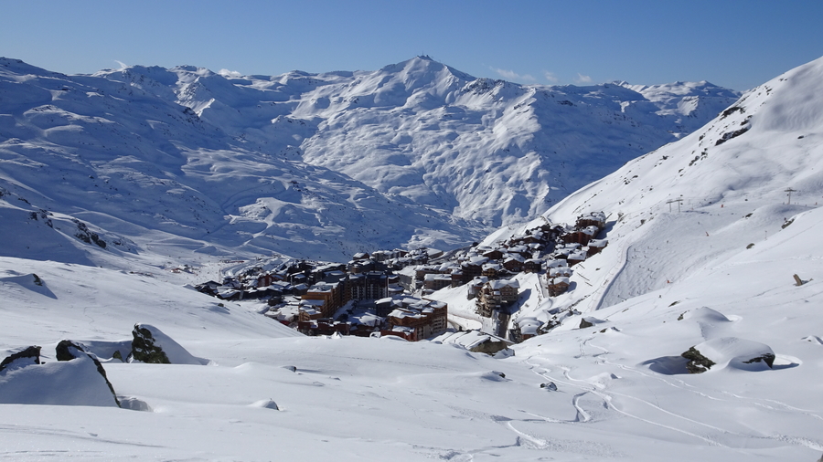
Val Thorens (2300-3200m)
At an altitude of 2300m, resorts don’t get much higher than this. 99% of the ski area is positioned above 2000m which ensures the best quality snow during its long season. Val Thorens is with a doubt an excellent bet for good snow conditions. Europe’s highest major skiresort is naturally one of the continent’s most snowsure right from the start to the end of winter. As well as the altitude advantage, Val Thorens also has a high proportion of north-facing slopes and access to not one, but two glaciers. Val Thorens is so confident of its snow cover it offers a snow guarantee.
Sank Christoph am Arlberg (1740-2811m)
Located in the famous Arlberg region and sandwiched in-between Lech, Stuben and Sankt Anton -which are all very snow sure resorts- tiny Sankt Christoph adds altitude to the equation. Settled in front of the Flexenpass at an altitude of 1740m it is one one of the best destinations for early or late season skiing in Austria.
Obertauern (1650-2320m)
Austria’s only purpose-built resort also comes with its own micro-climate and was cleverly positioned just so for access to the finest snow. Long term records reveal a snowfall average in Obertauern of nearly 8m, with the encircling peaks of the Niedere Tauern mountain range causing an ice-bucket effect that keeps temperatures super low.
Tignes and Val dIsere (1550-3456m)
Tignes sits above the treeline at 2100m with a top lift height of 3456m on the Grande Motte. Tignes is open before all other ski resorts in Europe and is the last to close its tracks. Like neighbouring Tignes Val d’Isere can get significant snow from storms of both Atlantic and Mediterranean origin. Tignes and Val dIsere are amongst the most reliable resorts in Europe for good snow due to the extent of high altitude skiing (60% of its 300km of slopes are above 2500m).
Schrocken-Warth (1270-2450m)
With it’s own micro-climate making things colder and more precipitous than others in the area, Warth-Schrocken averages over 10m of snowfall each year. Long term records taken at just 1600m show a seasonal average of nearly 11m of snow. Even in bad years Schrocken and Warth are snowier than many of it’s higher-altitude rivals.
Breuil Cervinia (1520-3820)
At 2050m, Breuil Cervinia is one of the highest resorts in the Alps, guaranteeing excellent, snow-sure skiing throughout the season and into summer.
La Rosiere (1176-2800)
La Rosière is the snowiest ski resort in the Tarentaise. La Rosiere has the benefit of being sited on the sunnier yet still snow-sure southern side of the domain, This is explained by its exposed position perpendicular to storms funnelling up the valley from the west.
Andermatt (1445-2965)
Andermatt has a big reputation for snow that few Alpine ski resorts can rival. Key to this is the way it benefits from storms arriving from different directions. The resort is equally likely to get dumped on from the north, the west or the south, and is therefore an excellent place to hedge your bets. The main Gemsstock mountain is also high and shady, so the snow that does fall sticks around, and is often in good condition.
Les Arcs (1800-3225)
The snow-sure, high altitude resort of Les Arcs is an excellent end of season destination. The skiing rises as high as 3225m on the Aiguille Rouge summit, and in good conditions stretches down to the tree lined pistes at 1200m. It’s an excellent variety of terrain.
Passo Tonale (1200-3016m)
Tonale is a high-altitude resort perched in a wide, open expanse that is both snow-sure and sunny. It is actually one of Italy’s highest resorts and is guaranteed good snow and a long season. Presena is the glacier just south of Passo Tonale which sits at over 2700m, so this coupled with the generous snowfall makes Tonale the perfect spot for powder seekers. Incidentally, Tonale is one of the cheapest snow sure destinations.
Operations level
The table presented below displays the average operational percentages for ski slopes and ski lifts during the ski season. These figures serve as indicators of the likelihood that the entire ski area may not be fully operational on any given day. Factors influencing this include adverse weather conditions, such as high winds and avalanches, or issues related to the age and maintenance of ski lift systems. Notably, resorts like Val Thorens, Les Arcs, and Obertauern have demonstrated a consistent track record of high operational levels, underscoring their reliability in terms of ski area accessibility.
| Slopes | Lifts | ||
| 1. | Val Thorens | 80% | 80% |
| 2. | Sankt Christoph | 63% | 78% |
| 3. | Obertauern | 87% | 84% |
| 4. | Tignes Val dIsere | 74% | 76% |
| 5. | La Rosiere | 79% | 82% |
| 6. | Schrocken Warth | 71% | 78% |
| 7. | Breuil Cervinia | 67% | 68% |
| 8. | Les Arcs | 82% | 86% |
| 9. | Andermatt | 73% | 76% |
| 10. | Passo Tonale | 65% | 75% |
Micro-climate
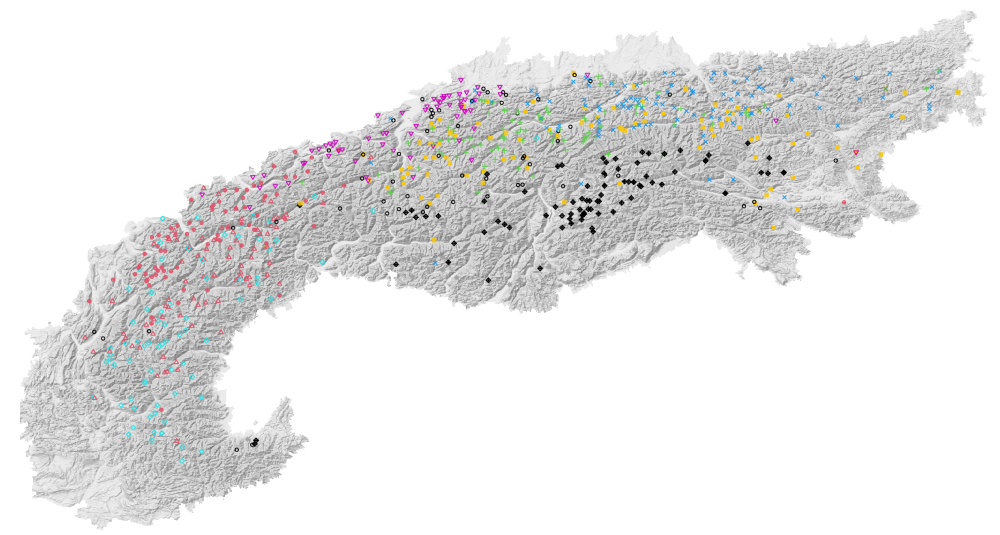
In our expanded research on snow reliability at ski resorts, we delved into the spatial variability of complete snow depth and temperature time series. This analysis aimed to identify resorts with similar micro-climate profiles.
The accompanying map presents all the ski resorts covered in our study, marked to indicate their micro-climate profiles. These identifications are based on a time series-profile analysis conducted over a decade. The map illustrates a classic north-south division along the main Alpine ridge and distinguishes between the Western and Eastern Alps. However, within this geographical layout, there’s noticeable differentiation, suggesting that storm fronts impact sub-regional climates differently. A prime example of this is the Northern Alps, especially the area below the Bodensee, such as The Arlberg region, which exhibits a diverse range of climate profiles or clusters, partly due to the region’s susceptibility to Fohn winds.
The key takeaway is the realization that proximity between ski resorts doesn’t necessarily equate to similar weather patterns and snow conditions. This is particularly evident in the Northern Alps regions like Tirol and Vorarlberg, where micro-climates can vary significantly even among closely situated resorts.
The cluster id is included in the snow-sure ranking.