Cervinia 2269m
offline
Cervinia 2269m
Resort
Breuil Cervinia
GPS 7.6307 E 45.9373 N
Altitude 2050 m
Valley
Valtournenche
Mountain range
Walliser Alpen
State Aosta
Skiarea Matterhorn ski paradise
Vertical drop 1620 - 3899 m
Local time 11:08 day
Sunrise - sunset 06:30 - 20:24


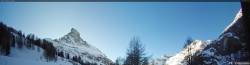
at the bottom of that mountain thre is a corie a corie is where a glacier had abarased and plucked the surface which would have been at the bottom and when the snow and glacier melted that is where the water comes from. also you can find a arette between two corries an erete is border line (very thin) or (very fat) in some cases between two cories. if you want any more information then contact me on my email jnm338@aol.com.